-40%
Montana Gold Mine Silver Placer Mining Claim Taylor Creek Panning Sluice Gems
$ 3141.6
- Description
- Size Guide
Description
Taylor Creek MineDepartment of Land Transfer Info
Equipment
Feedback
Other Claims for Sale
Contact Us
Add To Favorites
"Carlin Gold" Mining Claim
20 Acre Unpatented Placer Mining Claim
on Federal Land Montana
This placer gold mine totals over
1,306 feet
of creek. With this claim you will be getting the exclusive mineral rights to 20 acres on an excellent spot on the creek for you to work at your leisure.
Commodities (Major) - Gold Deposit
Elevation:
6500 feet
Access:
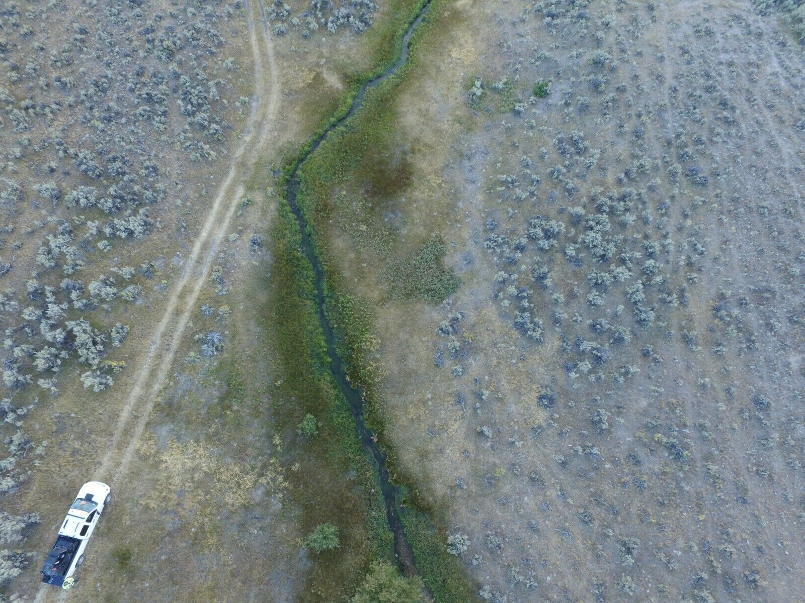
(For maps / location scroll towards the bottom of the listing) Taylor Creek can be accessed via 2WD, the road ranges from about 6-35 ft. away from the creek so there is very minimal walking involved. There are plenty flat areas throughout the creek for camping which will be convenient to park vehicles as well.
Acres:
20
Type
: Placer
Mining District
: Bannack
County
:
Beaverhead
(Fairly easy 2WD)
The Taylor Creek placer mines are located approximately 70 miles South-East of the Taylor Creek Lode Mine.
The Taylor Creek Mine is a lode and is a large open pit on a hillside in iron-stained, Precambrian Belt, banded argillites and quartzites. The area was considered active and had a valid mine permit with the Forest Service. The Taylor Creek Mine is upslope from the Larrigon Mine.
The Montana law states that rivers and streams capable of recreational use may be so used by the public regardless of streambed ownership. It also states that certain activities require landowner permission.
Because the law affects your rights and responsibilities as a landowner or recreationist, the information that follows may be of interest to you may want to look into the "Stream Access in Montana Brochure"
Recreational mining must adhere to closures and restrictions indicated in the Instream Mining Stream Classification list.
RECREATIONAL:
For Fishing License purchase, fishing rules, and fishing regulations please visit Montana Fish & Wildlife. Please remember to check with the local Fish and Wildlife department to ensure the stream is open to the public.
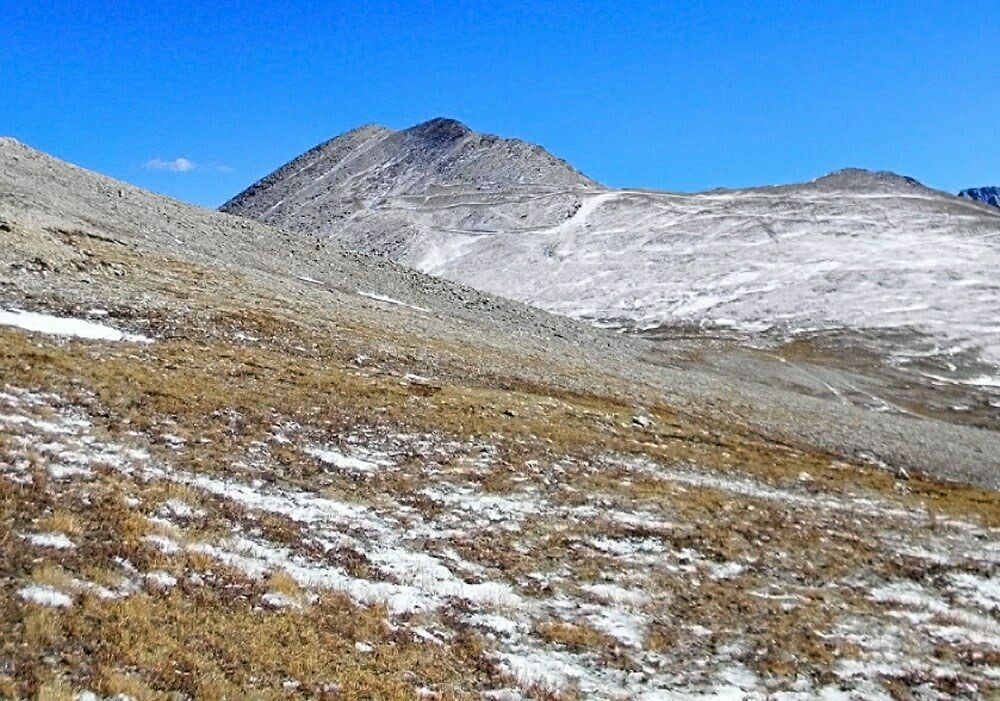
Views from above and of surrounding area
Taylor creek resides in the Bannack mining district. It was the site of the first major gold discovery in the Montana Territory; it was the first territorial capital; it was the first county seat of Beaverhead County; it saw the first lode mining in Montana Territory and it was the location of the first successful dredging operation in the United States. Mining began in 1862 and continues sporadically on a minor scale today. The main periods of mining in the Bannack area were the early placer, hydraulic and lode activity (1862 to 1875) and the dredging of Grasshopper Creek (1895 to 1902).
There is lodging and camping facilities approximately 14-20 miles away
This claim is located near the famous Bon Accord Placer mine as seen in the above map. The site area of the Bon Accord placers, about a half mile stretch of disturbed gravels, was first worked during the initial Bannack gold rush by placer miners who staked claims on the placer grounds along Grasshopper Creek from the town of Bannack down through the canyon to the mouth of Spring Gulch. The early miners, however, lacked the equipment and capital needed to work the 35-foot gravels down to bedrock and, following the initial rush, little further mining occurred in the area for the next two decades (Sassman 1941; Wolle 1963).
The first large-scale mining of the Bon Accord placers began in 1885 when the Bon Accord Mining Company was organized to work the placer gravels down to bedrock by hydraulic means. A patent for the Bon Accord Placer claim was granted to Thomas Lancey and others on September 4, 1888 (Mineral Survey #708; Pat. #14270). The Canyon Ditch, which tapped the waters of Grasshopper Creek, was built at a cost of 00 to provide water to the diggings. The company also built 500 feet of flume and tunneled the ground 35 feet below the surface to bedrock during the winter months. A Leffel waterwheel was used to drive the pumps which were used to keep the tunnels dry but it remained difficult and dangerous work.
The road is about 200-800 ft. away from the creek, so there will be some walking required. One thing you will notice is that some ranchers have set up barbed wire fencing for grazing, but this does not restrict accessing the creek.
Buyer will receive the following with their completed transaction:
Quitclaim deed showing full ownership of the claim. This will be stamped, recorded and verified with the County and the BLM offices.
Welcome packet with all of the rules and regulations as they relate to the State and BLM where the claim is located.
Educational documents to annually renew your mining claim with the BLM.
A CD of all of the documented images of the claim including maps of the site.
Map of claim marked and GPS coordinates.
Multiple maps showing claim location and surrounding areas for access.
Under the Montana Stream Access Law, the public may use rivers and streams for recreational purposes up to the ordinary high-water mark. Although the law gives recreationists the right to use rivers and streams for water-related recreation, it does not allow them to enter posted lands bordering those streams or to cross private lands to gain access to streams.
House Bill 190, passed during the 2009 Legislative Session, confirmed that the public has access to surface waters by public bridge or county road right-of-way. The Department, in cooperation with the affected landowner and county, is responsible for providing public passage around or through a fence preventing such access. A typical access feature would be a stile, gate, roller, walkover, or wooden rail fence. ( https://fwp.mt.gov/fishing/guide/access/streamAccess.html )
Come to Hike, Camp, Ride and Shoot - or come to pull some shiny rock$ out of the ground;-)
A recreational miner with a pick, shovel or gold pan does not need a special permit on BLM land in Montana. A person using a suction dredge in Montana should get a permit from the
Water Protection Bureau
,
Department of Environmental Quality
, 1520 East Sixth Ave. PO Box 200901, Helena, Montana 59620-0901,
phone 406 444-3080
. If the suction dredge intake is less than 4 inches in diameter, a general permit is required. If the dredge intake is larger than 4 inches, a more complicated permit is required for which there is a significant charge. The Montana Department of Natural Resources and Conservation and the US Army Corps of Engineers may also require permits for suction dredging.”
https://nandugreen.typepad.com/chasing_the_wind/2009/08/recreational-gold-prospecting-on-public-land.html
Discharges Associated with Portable Suction Dredges
The purpose of the Portable Suction Dredge General Permit (General Permit) is to regulate wash water effluent from portable suction dredges, to state waters in accordance with effluent limitations, monitoring requirements and other conditions set forth in Parts I, II, III and IV of the General Permit. A written authorization letter from the Department is required before an applicant is authorized to discharge under the General Permit.
https://deq.mt.gov/Water/WPB/mpdes/suctiondredge
You can access the claim by 2WD, just be cautious of weather, since that can determine certain road conditions in the area. Taylor Creek Rd, will lead you to the claim. There is an unnamed road that branches off, taking you directly to the creek, and where the claim is located. There is a slight hillside, from the road, down to the creek, so we advise caution when parking and walking down to the creek. It’s about 600-700 feet between the road and the creek. There is enough space for staging equipment, small camper or trailer, and parking.
The Larrigon Mine is located in the Taylor Creek drainage, in close proximity to the Taylor Creek Mine. The remains of the workings include three cabins, a wooden ore chute, and part of a foundation, possibly from an old mill. A waste-rock pile near the base of the slope may have been from underground workings, although no adits or other openings were observed. A small pile of sandy material near the mill may be tailings. The pile was about 12 to 15 feet from Taylor Creek and is isolated from the drainage by the road. Unpublished material in the MBMG mineral property files indicates the Larrigon was discovered in 1918 (Anon, [n.d.], MBMG files).
ABOUT THE MINING DISTRICT
Bannack's placer mining period was brief, violent, rich in gold and the source of an equally rich lode of historical legends. More than a ton of gold was taken from the Grasshopper diggings during the first season. Not only were the placer bars easily worked and incredibly rich, they produced some of the purest gold found anywhere in the world. On the average, Bannack gold assayed at 990 fine (99% pure) and in a few cases it went as high as 999 fine - essentially a chemically pure state (Cushman 1973).
Bannack's place in the history of gold mining is secure as it is ranked as one of Montana's most colorful and productive historic gold mining camps. Although records as to total production figures are either non-existent or unreliable, it has been estimated that the Bannack mining district has produced approximately ,000,000 in gold from 1862 until 1930 (with gold priced at .67 per ounce). The placer operations alone during the period from 1862 to 1876 produced an estimated ,000,000 worth of extraordinarily pure gold (Shenon 1931; Sassman 1941).
The geology of the Bannack district is described by Winchell (1914) as consisting of Paleozoic limestone intruded by a small stock of granodiorite. Immediately above this limestone layer are a few remnants of the Quadrant quartzite. The principal granodiorite intrusion is nearly circular and is on the south side of Grasshopper Creek south of the town of Bannack. A minor granodiorite intrusion is found on the north side of the creek just west of Bannack. Tertiary deposits, west of Bannack, extend over the surface for a number of miles both to the north and south. The ores found in the Bannack mining district are usually found in contact deposits but some minor ore bodies are in fissures. The ores have been valuable almost solely for their gold content, but they also contain some silver, lead and copper. The ore bodies are generally found along the contact between limestone and granodiorite, or in stringers or small fissures. Large amounts of garnet, with some epidote, are also found along the contact.
From the late 1860's to the 1930's, Bannack continued as a mining town with a fluctuating population. By the 1950's gold workings had dwindled and most folks had moved on. At that point the State of Montana declared Bannack a State Park. Today, over sixty structures remain standing, most of which can be explored. People from all over visit this renowned ghost town to discover their heritage. The Montana Department of Fish, Wildlife, and Parks governs the townsite and surrounding area of Bannack.
Mining claims are a tangible asset just like any other Real property (real estate) and show a lifetime proof of all interests in minerals in the area specified by the above claim. Once you own this claim and the associated mineral rights, you will own them for life as long as you keep up with the annual fees. This claim can be bought, sold, leased or used as collateral, just like any other piece of real estate.
A mining claim can be willed or passed down to future generations as part of a trust or your estate, or you can trade it, lease it out for a period or time (or indefinitely), gift it to a family member or friend and you can also transfer or sell just an interest in it in part or in its entirety just like any other real property using a quitclaim deed which is a recordable conveyance. In other words, you could sell a 25% or a 50% share in it if you wanted in order to bring on a partner in the future - or you could sell the entire claim in whole.
This is for full/all interest in this 20.66 acre lode mining claim (unless the acreage indicated in the above mine description is different). This claim covers the entire site, (unless the claim description above describes different measurements), and includes full rights to all minerals, gems and just about whatever else you may find of value on the property (except oil and gas, which are handled separately). The new owner of this mine will receive a notarized quitclaim deed to the full claim and all associated documentation showing full ownership of the claim. We pay ALL fees associated with transferring this claim into your name - legal fees, title transfer fees, document fees, notary costs, recording fees and even shipping fees, so all you will pay is the final price of the auction, not a penny more.
In order to hold on to your claim for life, you will need to pay an annual maintenance fee to the Government (BLM, not us) every year. Currently the maintenance fee is 5 per year per claim that you own, and it is due on September 1st of every year.
NOTE that if you own fewer than 10 claims nationwide, we can assist you in filing the paperwork to waive the maintenance fee every year. That means you will only pay per year for your maintenance fee instead of 5. We guarantee that all past fees have been paid in full and there are no outstanding debts or amounts owed on the claim prior to the transfer of ownership into your name.
The federal government retains ownership of the land - so this means that you will not have any annual real estate taxes due on your mining claim, and you will not have to maintain liability insurance in case someone gets injured on your claim due to no fault of your own.
How do Transfers of Ownership in Mining Claims work if I decide to sell my claim in the future?
First, we handle all the paperwork and costs associated with transferring this claim into your name. But if you decide to sell this claim at some point in the future, interest in a properly recorded mining claim or site may be transferred (i.e sold) in part or its entirety. A quitclaim deed or recordable conveyance document is required and if you do sell your claim someday and the transfer documents should be filed within 60 days after the transfer.
We can and will help you with the paperwork for no cost should you need a hand selling your claim in the future if you pay all of the County, State and Federal fees (usually less than to ).
But again - with regard to transferring this claim initially into your name, we take care of all the paperwork at our expense. You do not have to worry about anything. we handle the BLM transfer documentation and the county recording.
Can you build / camp on your claim?
Without an approved plan of operations, you have the same rights and restrictions as the public. If the area is open to camping to the public, then it is permissible. However, you need to check with the BLM Field Office or the local District Ranger for areas open to camping. Under Federal law in order to occupy the public lands under the mining laws for more than 14 calendar days in any 90 day period, a claimant must be involved in certain activities that (a) are reasonably incident; (b) constitute substantially regular work; (c) are reasonably calculated to lead to the extraction and beneficiation of minerals; (d) involve observable on-the-ground activity that can be verified; and (e) use appropriate equipment that is presently operable, subject to the need for reasonable assembly, maintenance, repair or fabrication of replacement parts. All five of these requirements must be met for occupancy to be permissible.
Although it is possible to build a permanent structure on a mining claim, it is extremely expensive and you will have to jump through way too many hoops to consider it easy to do. It would have to be in support of a commercial, year-round mining operation for starters, and you would need to post a large reclamation bond to insure that if you ever abandoned your claim, the bond would pay for the removal of the structure and the reclamation or the area. So in short, it is technically possible to build on your mining claim, but just be aware that it is very difficult and expensive to do - however, camping is almost always involved unless your claim is in a wilderness area, which is not very common at all.
Proud Member of:
In addition to handling all of the paperwork to transfer this claim into your name, as well as paying all of the fees so you do not have any costs other than the final price of the auction when the bidding closes, we also pay all of the costs associated with mailing the paperwork to you as well as to the County and Federal Government for recording and sending you back certified copies.
We will ship you a folder with all paperwork, claim coordinates, maps and information on your claim, including a CD-Rom with all of the pictures of your claim upon your payment in full clearing. We ship everything to you the same business day (if payment is received by 1:00 PM Pacific Standard Time) - and we will always provide you with the tracking information so you are always informed.
You initial claim packet that we mail has an unrecorded deed so that you can show ownership immediately after payment and be able to visit your claim. A second original deed goes to the County for recording the same day, and a third original deed goes to the BLM for certification as well. Both of those originals will be returned to you so you will wind up with several original deeds - but the County and BLM deeds can take 3 to 6 weeks to be returned to you, which is why we send you the initial original on day one.
Your payment of this eBay item in full gives you 100% ownership of this entire claim, with no other fees and/or other costs for the transfer of ownership required. This is NOT for the down payment, this is NOT a partnership arrangement where someone else will own part of the claim with you, and there are NO other fees or costs for the transfer of this claim in your name.
eBay does not allow checkout on the eBay website for any Real Estate transactions - simply because it is not like selling a widget - the transfer of real estate is complicated and requires notary work, licensed professionals and recording. Note that this is eBay’s rules and not ours and it is the same for any mining claim seller on eBay
We also are not able to accept PayPal payments for mining claims, as claims are real estate and PayPal does not allow payments to be made on any real estate items, including single family homes, condos, mining claim or land purchases. We DO accept just about every other kind of payment method you can think of: Personal Checks, Business Checks, Cashier's Checks, Money Orders, Bank Wires, ACH payments, Direct Bank Deposit at any Bank of America Branch, Gold or Silver Bullion (at the day’s SPOT prices), etc. After the auction close, we will send you a secure link to handle the payment safely online if you prefer, and we can also take care of payment by mail or telephone, as we are a traditional Brick and Mortar business - so whichever method you prefer is perfectly fine with us.
We provide financing plans with no interest or fees. Financing terms are minimum of 0 down with the balance will due within 90-days via three equal monthly payments of the remaining balance after the down payment has been paid.
With all financing plans, we do not transfer the final deed into your name until the claim has been paid in full. In the event of a default on a payment plan, we do not refund your down payment - however, we do allow you to put that down payment towards any other purchase as a store credit in full. If you are financing a climate and there is less than 90 days until September 1st (i.e. from June 1st through September 1st), when the annual fee for mining claims is due to the Federal Government, we will add the 5 maintenance fee to your down payment and pay it to the BLM on your behalf thereby increasing your down payment to 5 instead of 0 - however, the 5 portion of the down payment does not go towards your principle balance since it is used to pay the annual fees to the government, therefore the actual down payment credit will still be 0. Approval for financing is automatic as long as you have a valid eBay account in good standing.
